Saturday, August 17, 2013

Harney Peak- The High Point of South Dakota

Harney Peak:  7242 ft
Climb Date:  August 2nd 2013
Trailhead:  Sylvan Lake
Start Time:  2:00 pm
Finish Time:  4:40 pm
Climbing Time:  2 hours 11 minutes
Elevation gain:  1,300 ft
Distance Traveled:  7 miles round trip


I call it our family's "Great American Griswald Vacation."  We rented a van, packed our family and my parents into it and headed for the Black Hills of South Dakota to do all the things that tourists do. I must admit it was a great trip (minus the numerous motorcyclists- but we knew we would have them around).  We visited Mt Rushmore, Crazy Horse, Wind Cave, Jewel Cave and Custer State Park.  Once I found out that the highest point in the state, Harney Peak, was right there in the area, I felt I must to climb it.

The rest of my family did not want to hike it and decided to go on another hike around Sylvan Lake.  I was given about a two hour window to get up and down the mountain.  I realized this may be an unrealistic time frame as a sign at the trailhead stated to allow 4-5 hours to climb it.  I took the challenge to crush the time and blazed up the trail.

It was a warm afternoon and all the clouds and rain that engulfed us in the morning had burned off by noon.  Normally I'd have been skeptical of on coming afternoon storms, however the skies were clear with full sun.  The trail was well used and marked.  It was a mellow hike up through the forest that was very lush and green from the recent rains.  I passed a few people on the way up.  Half way in, I came to the forest registry and signed in.

The trail undulated a while before starting a steady climb.  Within a quarter mile from the summit the  trail split to the south and climbed to an open spot with great views to the East.  The forest thinned and the trail turned into a series of rock steps to the granite base of the summit.  The trail led into a partial cave where grated stairs were constructed and climbed a few stories to the summit and the summit's stone fire tower.


The fire tower was three stories tall and had multiple rooms.  There was a terrace constructed on the West side of the tower.  A lower opening in the tower gave access to the adjacent granite domes that formed Harney's West massif.  There were only a couple of people on the neighboring rocks, so naturally I sought the solitude and ventured over on what turned out to be a fun scramble.  I met a nice gentleman who hiked to the summit every year on his birthday.  He was 67 on this day.  He had a son that had lived in Colorado Springs.  He had climbed with his son in the Sangre De Cristos and Humbolt Peak.  It was nice to talk to him.


The weather was beautiful- sunny, cool and a nice breaze.  The views were unobstructed of the surrounding mountains, granite spires and the Eastern planes.  I took a bunch of summit photos, ate a cliff bar and headed on down.  I had lost track of time and spent neatly 40 minutes on top.  I put the afterburners on and jetted down the trail.  I had the trail to myself after the first quarter mile.  I initially passed a few people that were ascending who I had passed when I was going up.  I jogged some of the way down and made it back to the trailhead and car safely to find the rest of my family patiently waiting for me.  I have now made it to the high point of three states- NY, CO, SD (should have been four if I topped out on Rainier).  I'm not sure if hiking/climbing all state's high points is something I want to commit too.  I think I'd rather climb higher peaks around the world.  Thanks for reading...next blog will be about getting my Dad, Mom and Dawson up Beirstadt (a 14er).

Thursday, August 8, 2013

Mt. Shavano and Tabeguache Peak: Two Colorado 14ers


Climb Date:  July 21st, 2013
The 14ers:  Mount Shavano 14,229 ft and Tabeguache Peak 14,155 ft
Trailhead:  Shavano (Blank Cabin)
Start Time:  6:12 am
Finish Time:  2:40 pm
Climbing Time (round trip):  3 hours 4 minutes
Elevation Gain:  5,600 ft
Distance Traveled:  11.25 miles

Jeff and I returned to Shavano after being there six weeks earlier for a training climb in preparation for Mt. Rainier.  This time instead of carrying large and heavy backpacks, we traveled light.  I donned a 12 lbs Camelback M.U.L.E.  Our goal was to climb both Shavano and Tabeguach in combination.

I left for the trailhead Saturday, the day before our climb, to camp and get a better night's sleep as opposed to waking in the wee hours to leave Denver.  Jeff on the other hand had to take care of his dogs and wasn't able to leave until 2 am Sunday morning- ouch!  It was nice and relaxing to get out of town leisurely.  After stopping for some food and a Sonic Peanut Butter and Fudge shake in Conifer I cruised to the trailhead.  I  encountered some wild animals free grazing on the range during my drive on Forest Rd 252.

Wild Animals
More wild animals causing a traffic jam

I reached the trailhead shortly after 7 pm and continued up the road 252 to an open meadow that offered exceptional dispersed camping.  I set up my tent and kicked back to watch the sunset over Shavano.
Camp amongst the aspen groove (and some wild flowers) 

Sunset view from my camp chair (Shavano looms above- second hump from the left)


I slept well and woke to my alarm at 4:30 am.  Just as I woke, Jeff texted me saying he was in Fairplay and having a tough drive due to sleepiness.  He had to pull over on Kenosha Pass to catch a few z's.  We oringinally were planing to meet at the trailhead around 5 am, which would now be later.  So I slept in until 5, got up, packed up and drove to the trailhead where I set up my camp table and stove to make some oatmeal and tea for breakfast.  There were already a few hikers getting an early start.

Jeff arrived around six safely and we were on the trail by 6:12 am.  Our climbing route differed from our last trip as we took the standard route up Shavano instead of the Angel route.

The Angel has melted away

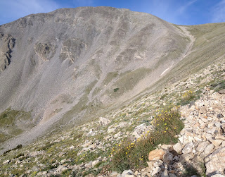
 Climbing the trail with Shavano's summit above us.

Jeff on the South Saddle of Shavano 

We made it to the top of Shavano in three and a half hours, 9:40 am.  This was quite a bit faster than our last climb on this mountain with 40lbs on our backs, which took us five hours to summit.  We continued over Shavano's summit without stopping and headed down it's North ridge toward Tabeguache.  The weather looked agreeable for heading over to Tab.  The ridge was a bunch of large talus blocks which made the down stepping easy.  We reached the saddle between Shavano and Tab, grabbed some energy food and spied the route up Tab.  The route looked steep and loose.

Tabeguache's East Ridge seen from Shavano's North Ridge

We ascended Tab's East ridge where the trail was faint and a mixture of loose dirt/scree and talus.  Once on the first false summit, the route was more enjoyable and you could see the true summit.  We reached the top of Tab fifty-four minutes after being on Shavano's summit, 10:34am.
Tab's summit

Antero in the background of Jeff and I

After hanging out on Tab's summit enjoying nutrients, the view and perfect conditions, we departed at 11 am.  Coming down the false summit toward the saddle, Jeff twisted his foot on talus which caused significant foot pain.  I gave him my trekking poles to ease the going. 
Back up Shavano's North Ridge

The climb back up Shavano was much more enjoyable than I had anticipated.  Jeff was slower and I kept him insight to make sure he was going to make it up.  I got to the summit of Shavano by 11:45 am, ate more food, chatted with another couple who were heading over to Tab (which I cautioned as the clouds were building).  I had them snap a picture of me and my GO BLUE flag.  Jeff made it up and we decided to follow the standard trail as it would be better for Jeff to negotiate considering his foot.
 
Second time on Shavano this day(4th time in my 14er climbing log)

The hike down was pretty smooth until we hit treeline, where my IT Bands started to scream at me.  Without my poles it was difficult and painful with each step.  My legs were clumsy and it took a good effort not to trip and crash.  In the forest, we heard thunder rumble up high on the mountains.  It was a great relief to be safe in the trees.  There is an area along the trail where numerous trees had been blown down by fierce wind a couple years ago.  My head was on a swivel noting which trees looked suspect to toppling over if the wind should have picked up on us.  Thank goodness it didn't.

We signed out on the trail register and made it back to the parking area of the trailhead with tired legs.  A successful day of a long climb of two 14ers.  I have one more 14er to climb to finish the Sawatch Range, Antero (one of our training climbs for Rainier that we were so close to completing if it was not for unstable snow on the final ridge to the summit).  I have now completed 34 of Colorado's 54 14ers and I have climbed 6 of them more than once.